
Measured Building Surveys in Newcastle-Upon-Tyne
At Project North Geomatics, our surveyors use the latest 3D laser scanning technology to carry all measured building surveys in and around Newcastle-Upon-Tyne. With accuracy being the most important factor in any measured building survey, 3D laser scanners allow for the capture of highly detailed and highly accurate data resulting in the production of fully comprehensive Measured building surveys.
Are you undertaking a project in Newcastle? To ensure the success of your next scheme, it is crucial to have a comprehensive understanding of the building's existing structure. This is where measured building surveys come into play. By providing accurate and detailed data about your property, these surveys empower you to make informed decisions, minimize risks, and maximize efficiency.
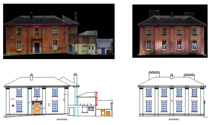
All measured building surveys at Project North Geomatics are conducted by trained professionals using advanced surveying instruments, such as 3D laser scanners, Total Stations, and Global Navigation Satellite Systems (GNSS). Among these technologies, 3D laser scanners stand out for their exceptional benefits, revolutionizing the field of measured building surveys.
Here's how using 3D laser scanners enhances the survey process:
High Precision and Accuracy: 3D laser scanners use laser beams to rapidly measure distances and capture millions of data points within seconds. This results in highly accurate and precise measurements of the building's geometry, ensuring minimal errors in the final survey data.
Speed and Efficiency: Compared to traditional surveying methods, 3D laser scanners dramatically reduce surveying time. They can quickly scan large areas, providing detailed point clouds that represent the building's shape, size, and spatial layout with exceptional efficiency.
Non-Intrusive Data Collection: Laser scanning is a non-intrusive method, meaning it doesn't require physical contact with the building elements. This is particularly advantageous for historic or delicate structures, as it minimizes the risk of damage during the survey process.
Capturing Complex Shapes and Details: 3D laser scanners can capture intricate architectural details and complex geometries accurately. This is especially useful for historical buildings with ornate designs or modern structures with unique features.
Reduced Site Visits: Due to the comprehensive nature of 3D laser scanning, the need for multiple site visits is significantly reduced. This helps save time and resources, making the survey process more cost-effective.
Visualization and Collaboration: The point cloud data generated by 3D laser scanners can be visualized in 3D modeling software. This provides a clear representation of the building, enabling better collaboration among project stakeholders and enhancing communication during the design and planning phases.
Clash Detection and BIM Integration: By integrating the point cloud data into Building Information Modeling (BIM) software, potential clashes between the proposed design and existing structure can be identified early in the project. This ensures smoother coordination among different disciplines and reduces construction conflicts.
As-Built Documentation: The accurate and detailed data obtained from 3D laser scanners serve as valuable as-built documentation for the building. This information is essential for future renovations, maintenance, or facility management purposes.


Useful Measured Building Survey Information:
-
Measured Building Surveys are an accurate and detailed way of mapping a building or structure internally and externally. Measured building surveys will identify all internal and external features of a building or structure from windows and door positions to internal walls and floor levels, all relevant features will be presented. Measured Building surveys consist of floor plans, internal and external building elevations and building cross sections.
-
Measured building surveys have a wide range of uses from residential and commercial to historic and restoration projects. Some of the main uses for measured building surveys include: Structural redevelopment, building extensions, refurbishment projects, change of building usage and building reconfiguration internally and externally. Architects, engineers and planners will use measured building surveys as a base for all major initial design work with a measured building survey offering an accurate representation of a building or structure allowing for accurate designs both structurally and visually. Inaccurate measured building surveys can lead to a number of issues for a project including increased costs or redesign, project delays, fines and planning problems both at the applications and completion stage. The main benefit of a measured building survey is accuracy and detail, these two factors offer the platform for design and planning work to be undertaken with confidence whilst maximising and utilising space available. Modern survey techniques allow for the capture of 3D point cloud data to further enhance deliverables for the use in BIM applications
-
All measured building surveys are carried out by fully qualified and competent surveyors. All measured building surveys are carried out to RICS guidelines working along side client specific specifications and requirements. All work is subject to rigorous quality control procedures to ensure the accuracy and detail of plans provided.
Measured Building survey information will be presented as 2D Floor plan, building elevations and sections as standard in AutoCAD format accompanied by digital PDFS.
Measured Building surveys can also be presented as a 3D model in Autodesk Revit format, which will be agreed at the tender stage of a project.


