

3D Laser Scanning Surveys

Project North Geomatics use the latest 3D laser scanning technology to carry all 3D laser scanning services and 3D data acquisition. 3D laser scanners allow for the capture of large quantities of data in a short period of time, optimising site time and data acquisition. 3D laser scanners provide the platform to capture highly accurate, detailed and dense 3D data resulting in the production of fully comprehensive 3D point clouds and 3D deliverables.
In the field of surveying, accuracy and efficiency are paramount. The advent of 3D laser scanning technology has revolutionized the way surveys are conducted, providing surveyors with unprecedented levels of precision and detail. In this article, we will explore the incredible benefits and applications of 3D laser scanning in surveying and how it is transforming the industry.


Laser scanning technology has emerged as a game-changer in various industries, revolutionizing the way we capture, visualize, and analyze spatial data. From architecture and engineering to construction and beyond, laser scanning offers a plethora of benefits that streamline processes and enhance project outcomes. In this article, we explore the advantages of laser scanning with a focus on its applications in different fields.
Speed and Efficiency
Rapid data capture: Laser scanners can quickly and accurately capture millions of data points in a matter of seconds, significantly reducing surveying time.
Fewer site visits: The comprehensive nature of laser scanning minimizes the need for multiple site visits, saving time and resources.
Faster data processing: Advanced software tools enable quick processing and analysis of the captured data, expediting project workflows.
High Precision and Accuracy
Pinpoint measurements: Laser scanners deliver precise measurements, offering sub-millimeter accuracy for critical spatial data.
Detailed representations: The resulting point clouds provide a detailed and accurate representation of the scanned object or environment.
Non-Intrusive Data Collection
Contactless scanning: Laser scanning is a non-intrusive method that doesn't require physical contact with the object, making it ideal for delicate structures and historical artifacts.
Minimized disruptions: During laser scanning, normal operations can continue without interruptions, ensuring minimal disturbance to ongoing activities.
Comprehensive Data Visualization
3D models and point clouds: The captured data can be transformed into 3D models and point clouds, allowing for immersive and detailed visualization.
Enhanced collaboration: Visual representations aid in better communication and collaboration among project stakeholders, facilitating effective decision-making.
Clash Detection and Quality Assurance
Clash detection: Laser scanning data can be integrated into Building Information Modeling (BIM) software to identify clashes between proposed designs and existing structures.
Quality assurance: Laser scanning allows for meticulous inspections, ensuring construction and manufacturing processes meet required standards.
Historic Preservation and Documentation
Cultural heritage preservation: Laser scanning plays a crucial role in documenting and preserving historic buildings, monuments, and artifacts for future generations.
Accurate documentation: The detailed data obtained through laser scanning serves as valuable as-built documentation for future renovations and restorations.
Safety and Risk Mitigation
Remote data capture: Laser scanners can access hard-to-reach or hazardous areas, reducing the need for personnel to enter potentially risky environments.
Early identification of issues: Laser scanning enables the identification of structural or safety issues in advance, helping to mitigate potential risks and prevent accidents.
Useful 3D Laser Scanning Information:
-
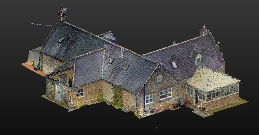
3D laser scanning produces a 3D representation of an object, building or structure which is referred to as a point cloud, the addition of on board HDR imagery also adds photo realistic colourisation and visuals to the 3D data. 3D laser scanning is a survey solution that is fast, data rich and non-intrusive which can often be a major advantage in areas of limited access, hazardous areas or completely inaccessible.
-
Project North Geomatics use 3D laser scanning across a range of projects from building restoration and development to highways, bridge and petrochemical projects due to the accuracy and wealth of information obtained and the non-intrusive nature of the process. We predominantly use 3D laser scanning in the production of 2D or 3D Measured building surveys as the accuracy is far superior to that of conventional techniques. One main benefit of 3D laser scanning is it is a key asset in heritage projects, historic building documentation and restoration as it offers a complete 3D representation of that structure or specific object at that time that can be stored for future reference or use in the event of structural damage or deterioration. 3D laser scanning, point clouds and 3D data are becoming a key part in any design-based project as clients are able to add a visual aspect to a design whilst seeing how their design will fit the space available both structurally and aesthetically which can save costly errors or re designs later in the project.
-
Laser scanning information will be presented as a cleaned and fully registered point cloud in various file types to best suit client requirements.
Ortho rectified images can also be provided in .TIF format
A TrueView link will be provided which allows for online access to the laser scan project, given the client the ability to walk through the site via the scan locations. Offering the ability to measure, explore, and mark up site information whilst been used as a visual aid during the design phase of a project.


Versatile Applications
The applications of 3D laser scanning in surveying are extensive and diverse. It is commonly used in various industries, including construction, architecture, civil engineering, and archaeology. Here are some key applications of 3D laser scanning:
a) Building Information Modeling (BIM): 3D laser scanning enables the creation of highly accurate and detailed 3D models of existing structures, facilitating the development of BIM models for renovation and construction projects.
b) Topographic Surveys: The detailed terrain information captured by 3D laser scanning is invaluable for creating precise topographic maps, assisting in urban planning, land development, and environmental assessments.
c) Structural Analysis: 3D laser scanning aids in structural analysis by capturing accurate measurements of buildings, bridges, and other infrastructure, allowing engineers to assess structural integrity and identify potential issues.
d) Cultural Heritage Preservation: 3D laser scanning plays a crucial role in documenting and preserving historical sites, artifacts, and monuments with unmatched precision, facilitating restoration and conservation efforts.
The Future of Accurate Data Capture
3D laser scanning has emerged as a game-changing technology in the field of surveying, offering unparalleled accuracy, efficiency, and detail. With its ability to capture millions of data points and generate highly precise 3D representations, it has revolutionized the way surveys are conducted across various industries. As the technology continues to advance, the possibilities for its applications in surveying are limitless, opening new avenues for innovation and improvement in the field. Embracing 3D laser scanning is not just an option
Unmatched Precision and Detail
One of the primary advantages of 3D laser scanning is its ability to capture an immense amount of data with unparalleled accuracy. Traditional surveying methods often require manual measurements and can be prone to human error. With 3D laser scanning, surveyors can obtain millions of data points within minutes, resulting in highly accurate and reliable surveys.
The level of detail captured by 3D laser scanners is truly remarkable. Every minute feature, from intricate architectural elements to subtle terrain variations, can be accurately represented in the resulting point cloud. This level of detail not only enhances the precision of measurements but also enables surveyors to analyze and visualize the surveyed area with exceptional clarity.

Enhanced Efficiency and Time Savings
Compared to conventional surveying techniques, 3D laser scanning significantly reduces the time required to complete a survey. With the ability to capture large amounts of data in a short period, surveyors can conduct surveys more quickly and efficiently. This time-saving benefit allows for faster project turnaround, enabling stakeholders to make timely decisions and proceed with subsequent phases of a project without unnecessary delays.
Furthermore, the collected data can be easily stored, shared, and accessed digitally, eliminating the need for physical documents and reducing the risk of data loss or damage. Surveyors can revisit the digital point cloud at any time, extracting additional measurements or conducting further analysis without the need for revisiting the physical site.