
Land Surveyors · North East England
Land & Measured Building Surveyors in the North East
Trusted topographic, measured building, 3D laser scanning and utility surveys across Newcastle, Durham, Sunderland, Northumberland, Teesside and the wider North East. RICS aligned, Constructionline and SSIP approved.
Trusted Land Surveyors Serving the North East
Based in Newcastle Upon Tyne, Project North Geomatics deliver a complete range of land surveying services right across the North East of England. From topographic surveys (commonly known as topo surveys) to measured building surveys, 3D laser scanning, underground utility surveys and more, our experienced surveyors use the latest technology to capture accurate, RICS aligned data on every project, large or small.
We work with construction, civil engineering and architectural clients throughout Newcastle, Gateshead, Sunderland, Durham, Northumberland, Teesside, Morpeth and beyond, mobilising fast and delivering on time.
The Latest Surveying Tech, On Every North East Site
Our North East land surveyors use a full kit of professional surveying equipment, including Trimble total stations, GNSS receivers, 3D terrestrial laser scanners, GPR utility detection and CAA approved drones. This blend of kit means we can produce fully comprehensive surveys for any North East site, from tight urban infill plots to large open quarries and rural estates.
Every survey is delivered in the format you need, whether that is 2D CAD, a 3D point cloud, a Revit BIM model, or a clean PDF. We follow the RICS Guidelines for Measured Surveys of Land, Buildings and Utilities (3rd edition) and apply strict quality control on every job.
Why Architects and Contractors Choose Us in the North East
Architects, structural engineers, contractors and developers across the North East trust us because we deliver. Same day quotes, fast mobilisation, accurate data, and a friendly team that picks up the phone. Whether you need a single house plot surveyed in Durham or a multi-site portfolio scanned across Newcastle and Sunderland, we will brief in, scope out and turn it round on time.
Surveying services in the North East
Land surveying services we offer across the North East
A complete range of surveys, all delivered to RICS guidelines and tailored to your North East project specification.
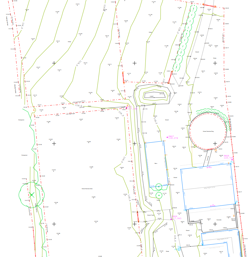
Topographic Surveys in the North East
Also known as topo surveys. We combine GNSS, total stations, 3D laser scanners and drones to produce fully comprehensive and accurate topographic surveys for North East projects of any size.
Learn more about topographic surveys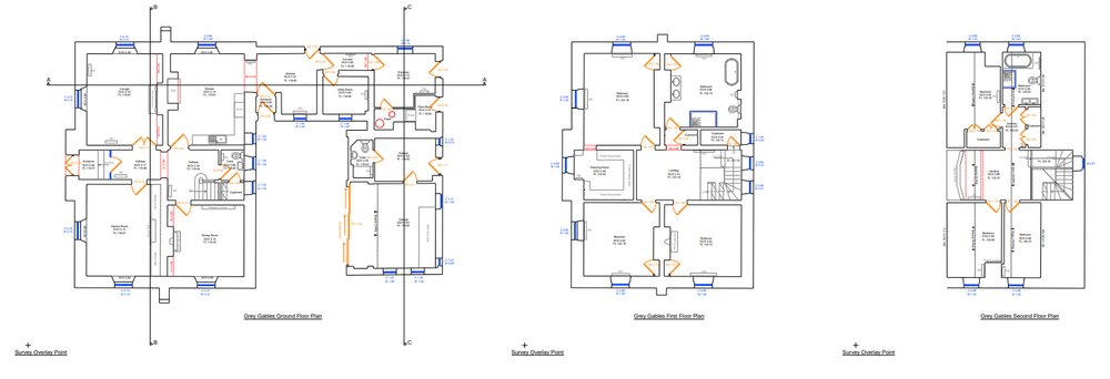
Measured Building Surveys in the North East
Using 3D laser scanning technology to deliver highly accurate floor plans, elevations and sections for residential, commercial and heritage buildings right across the North East.
Learn more about measured building surveys
3D Laser Scanning in the North East
Capture huge volumes of dense, millimetre accurate 3D data fast. Our laser scanning service supports BIM, heritage recording, structural monitoring and clash detection on North East projects.
Learn more about 3D laser scanning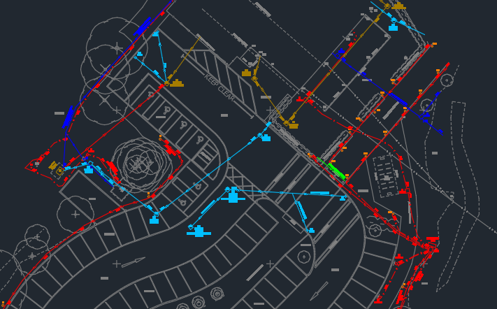
Utility Surveys in the North East
Underground utility surveys (also called GPR surveys) for the accurate detection of buried services across North East sites. Verify the position of pipes, cables and ducts before design or excavation.
Learn more about utility surveys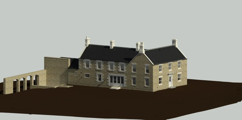
3D Modelling & BIM in the North East
From point cloud to Revit. We produce LOD compliant BIM models and 3D deliverables that drop straight into your architectural and engineering workflows in the North East.
Learn more about 3D modelling & BIM
Drone Surveys in the North East
CAA approved drone surveys for large or hard to reach North East sites. Fast, safe and high resolution aerial data capture for topographic mapping, volumes and visual inspection.
Learn more about drone surveysNorth East locations
Towns and cities we cover in the North East
From Newcastle in the heart of Tyne and Wear right through to Carlisle on the Cumbrian border, our North East land surveyors mobilise fast and deliver consistent quality at every postcode.
Pick your nearest location to see the work we have done there and the specific services we offer locally.
Why work with us
North East surveyors that deliver
Four reasons clients across the region keep coming back to Project North Geomatics.
Fast turnaround
Quotes back same working day. Strict deadlines met without compromising on accuracy.
RICS aligned
Every survey follows the RICS Guidelines for Measured Surveys (3rd edition). No corners cut.
Local team
Newcastle based with deep knowledge of North East sites, planning departments and access.
Latest kit
Trimble total stations, terrestrial laser scanners, GPR and CAA approved drones in every van.
Frequently asked
North East surveying questions, answered
Common questions we get from architects, contractors and developers commissioning surveys in the North East.
What areas of the North East do you cover?
We cover the entire North East of England, including Newcastle, Gateshead, Sunderland, South Shields, North Shields, Whitley Bay, Durham, Middlesbrough, Hartlepool, Darlington, Stockton, Northumberland, Morpeth, Alnwick and Hexham. We also work across the wider UK from Edinburgh down to Leeds.
How quickly can you mobilise to a North East site?
Most North East sites can be attended within a week of quote approval, often sooner for urgent projects. Quotes themselves typically come back the same working day. Send us your brief to get started.
What is the difference between a topographic survey and a measured building survey?
A topographic survey (or topo survey) maps the land, levels and external features of a site, ideal for planning and design work. A measured building survey captures the interior and exterior of an existing building, producing floor plans, elevations and sections. Both are commonly used together on North East refurbishment and extension projects.
Are you accredited to work on construction sites?
Yes. We are Constructionline Approved and SSIP Approved, and carry full professional indemnity and public liability insurance. We follow rigorous health and safety processes on every North East site.
What deliverables do you produce?
We deliver in any format you need: 2D CAD drawings (AutoCAD DWG), 3D point clouds (RCP, E57, LAS), Revit BIM models, PDF plans and orthophotos. Tell us what your design team needs and we will deliver it.
How much does a land survey cost in the North East?
Every survey is unique, so cost depends on site size, complexity, deliverables and access. Send us a boundary plan or Google Earth screenshot via our quote form and we will come back with a fully itemised, no obligation quote, usually the same working day.
Get started
Need a land surveyor in the North East?
Tell us about your project and we will come back with a fast, free, no obligation quote, often the same day.